Cities are getting bigger and more complex, and the changes in traffic, population, and businesses provide a wealth of information. However, shaping urban areas needs more than just guesswork. Location data plays a vital role in this, offering insights that help developers make informed decisions. This data helps urban planners improve living conditions, making cities more livable and green. By studying this data, they can reduce traffic, better support overlooked communities, and enhance local economies.
In this blog, we’ll look at how urban planning directly benefits from using location data to address city challenges. We’ll also consider the ethical aspects of using data and how advanced technology can contribute to building smarter cities for the future.
Location Data Scraping
Location data scraping is extracting geo-located information from various sources to analyse residents’ movements, behaviors, and preferences within a city. This data can be leveraged to understand city dynamics, identify trends, and inform decision-making:
- Understand population distribution and mobility patterns
- Optimise transportation systems
- Identify areas of need
- Support economic development
- Evaluate urban development projects
- Create smart cities
Sources of Location Data
Location data can be sourced from a variety of digital platforms, including:
- Social media platforms
- Mobile devices
- Online maps and directories
- Government data
- IoT devices
Combining data from multiple sources allows urban planners to create a comprehensive picture of city life and make informed decisions.
Evolution of Urban Planning
Traditional urban planning mainly uses information from censuses, land studies, and expert advice. While this was helpful, it wasn’t fully equipped to handle the intricate details of today’s cities.
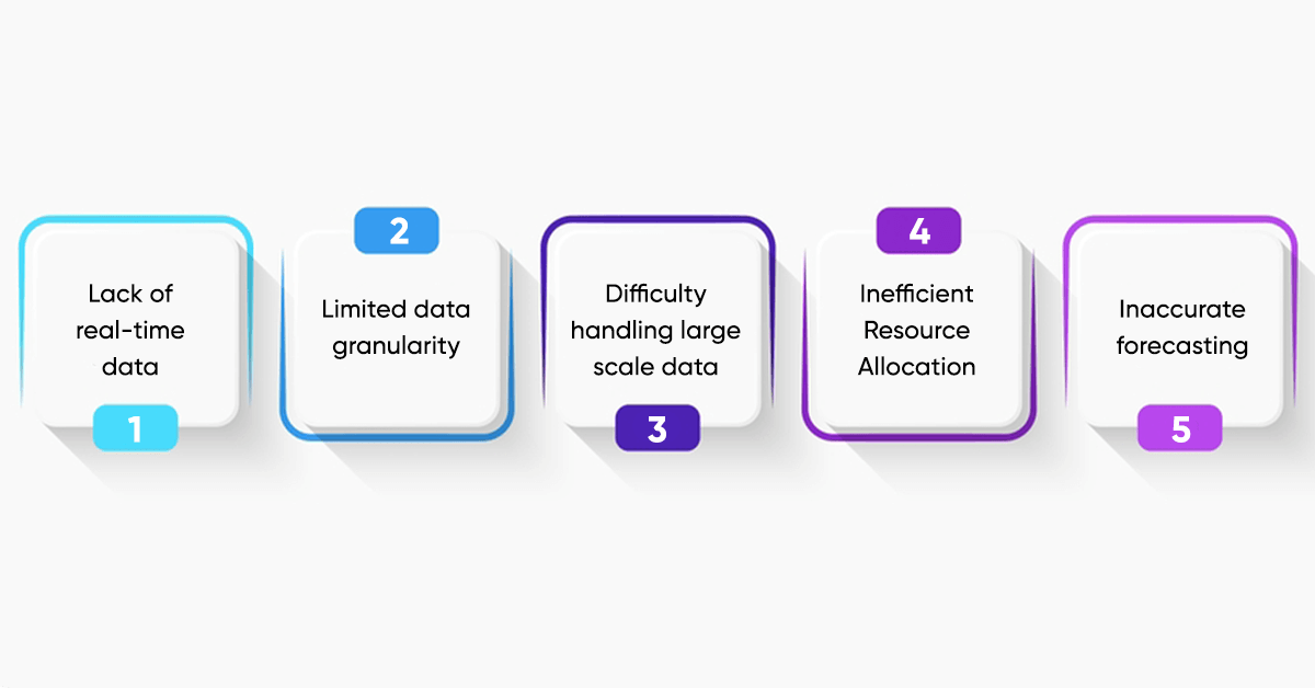
Limitations of Traditional Techniques
- Lack of real-time data: Old methods weren’t great at keeping up with city changes. Decisions were often made using old information, leading to mistakes and less-than-ideal results.
- Limited data granularity: Census data and land surveys usually gave a rough overview, which made it hard to see the small, detailed differences and trends within neighbourhoods.
- Difficulty handling large-scale data: Old techniques couldn’t handle or make sense of the huge amount of information that today’s cities produce.
- Inefficient resource allocation: Because there wasn’t up-to-date information on where people went, how traffic flowed, and how services were used, resources were not always used in the best way possible.
- Inaccurate forecasting: Predictions about how cities would grow and change were usually made by looking at past patterns and what experts thought, sometimes leading to wrong guesses about the future.
The Impact of Location Data on Urban Planning
Location data has changed how we plan and run cities. It gives up-to-date, detailed information about how people act and how city systems work, helping planners make decisions based on facts to better the lives of city residents.
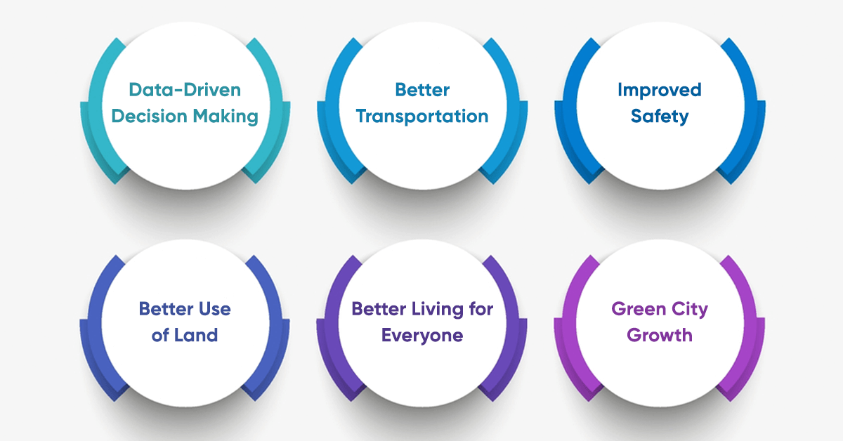
Data-Driven Decision Making: Using location data helps planners stop relying on guesses and make choices based on real evidence. By looking at how people move around, how crowded places are, and how resources are used, cities can use their resources smarter and more effectively.
Better Transportation: Knowing where traffic is heavy, how people use buses and trains, and where parking is in high demand helps improve travel routes. Live data can help change traffic lights when needed, change bus and train routes, and point out where more roads or other transport help is needed.
Improved Safety: Understanding where crimes happen and where emergency calls come from helps cities place police and emergency teams in the best spots to stop crime and respond to emergencies faster. Data about locations can also identify places that might be risky or have problems that need fixing.
Better Use of Land: By studying the number of people living in an area, what kind of business is happening, and who these people are, we can figure out the best way to use land. Location data can identify residential, commercial, or industrial development areas and inform zoning decisions.
Better Living for Everyone: Location data can identify communities that lack services. This information can help provide better healthcare, schools, and support services where they’re needed. It can also improve parks, sports areas, and fun places for people to enjoy.
Green City Growth: By examining our energy use, trash production, and environmental health, cities can make plans to reduce pollution and better care for nature.
Specific Use Cases
Predictive Analytics: Predicting how many people will live in an area, how much traffic there will be, and how much people will need services like buses or hospitals.
Smart Cities: Creating city systems that work together to use resources like water and energy better and improve life for the people there.
Emergency Management: Real-time monitoring of disaster events and efficient deployment of emergency services.
Economic Development: Finding new ways to grow, bringing in investments, and helping local businesses succeed.
Challenges and Considerations in Location Data Scraping
Getting location information can be really useful for city planning, but there are also some challenges to think about:
Technical Challenges
- It can be difficult to ensure that the information is correct, complete, and the same because it comes from different sources and in different ways.
- Keeping people’s personal information private and following the laws about protecting data is very important.
- Dealing with a lot of information and sorting it out well needs a strong infrastructure.
- Web pages change and use JavaScript, which can make getting data tricky.
- Scraping too much can cause websites to block access, so you might need to use proxies to get around these blocks.
Ethical Challenges
- Collecting and using location data raises ethical questions about individual privacy and data protection.
- It’s important to ensure the data fairly represents everyone and doesn’t leave anyone out or favour some groups over others.
- It’s also key to figuring out who owns the data we collect and how it might be used for business.
Legal Challenges
- Following rules like GDPR and CCPA is a must.
- It’s important to respect website rules and not scrape information that you’re not supposed to.
- Being careful not to break copyright laws when using scraped data is also crucial.
The Future of Urban Planning with Location Data
As technology continues to advance, we can expect to see even more innovative applications of location data in the following areas:
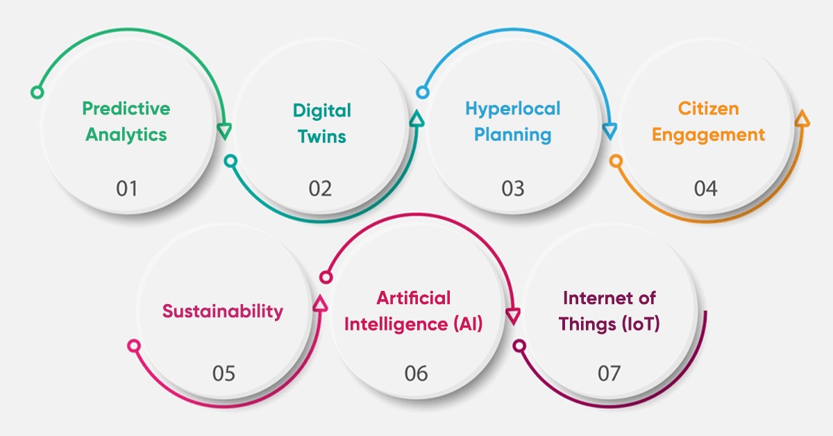
Predictive Analytics: Analyzing past location information to guess future changes like more people living in an area, more traffic, and a higher need for services. This helps city planners prepare and use resources wisely ahead of time.
Digital Twins: Planners can use this model to try out different ideas and see what might happen without making real changes.
Hyperlocal Planning: Using location data helps determine what different neighborhoods need. This allows cities to be developed in a fairer way that responds to each area’s requirements.
Citizen Engagement: When people help with city planning using location information, they feel more like they are a part of the process. This can help city projects work better because people are more involved.
Sustainability: Location data can show ways to reduce carbon emissions, save resources, and help make cities more sustainable.
Artificial Intelligence (AI): AI can analyze large amounts of location data, find patterns, and discover things that would be difficult for people to find on their own.
Internet of Things (IoT): Sensors all around the city can track things like air quality and road traffic, giving us a better picture of how the city works in real-time.
Conclusion
Location data is changing cities, helping planners make smart decisions to make cities more livable, efficient, and sustainable. With up-to-the-minute, detailed information, cities can improve transportation, use resources wisely, and improve public services. As technology improves, location data will become even more important in city planning. LocationsCloud provide high-quality, real-time location data to businesses, helping them make choices that will improve our cities in the future.